SW Alabama one of many rural, high-poverty areas facing radar gaps
LOUISVILLE, KY, UNITED STATES, January 3, 2025 /EINPresswire.com/ -- When severe weather threatens, rural communities across America often find themselves with fewer resources to cope – including access to the latest warning technology. Now, Louisville, KY-based Climavision helping solve that need with a network of gap-filling radars, including their latest installation in a critical region of the South.
Since the 1990s, the National Weather
Service has monitored severe weather across the country using NEXRAD S-band radars. However, gaps can exist between these systems as the radar beam moves higher in the atmosphere the further it gets from the radar location. Emergency officials and meteorologists have long recognized Southwest Alabama as one of the most prominent gaps, with parts of the area sitting well over 100 miles from the nearest NEXRADs in Birmingham, Montgomery, Mobile and Jackson, MS.Southwest Alabama is especially prone to large, deadly tornadoes and also faces some of the highest poverty rates in the nation. This is a particularly dangerous combination, leaving the region less prepared, less aware, and less equipped than urban areas to deal with weather phenomena that can go unseen in weather gaps - such as flash flooding, sleet, ice, and tornadoes. It’s part of what researchers refer to as “weather equity,” an issue being addressed in the Weather Reauthorization Act, which the next Congress will take up.
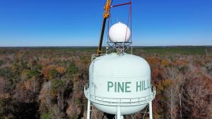
However, private companies are stepping up to help solve this issue as well. On December 12, Climavision installed one of its gap-filling X-band radars in Pine Hill, Alabama – near the center of this critical radar gap. After a few weeks of testing and calibration, Climavision will begin providing the data to local and federal partners, as well its clients in media, energy, agriculture, aviation and other industries. While all watches and warnings will continue to come through the National Weather Service, this new level of weather insight can make a critical diffrerence for local emergency agencies and the communities they serve.
“Having lived in south Alabama for many years, I know first hand just how much this area is at risk from severe weather,” said Climavision co-founder and CEO Chris Goode. “It’s especially meaningful for us to be able to provide these communities with the awareness they deserve, and to make it possible for our partners to serve them better as well.”
The Pine Hill system joins two other Climavision radars covering parts of Alabama – one in Moulton and one near Meridian, MS. The company is hard at work addressing other low-level gaps around the country, with 29 radars now operational and eventually scaling the network to more than 200 radar systems.
Climavision provides all of its radar data to the National Severe Storms Laboratory as part of a Cooperative Research and Development Agreement (CRADA). Some National Weather Service Weather Forecasting Offices (WFO’s) also have access to Climavision data through a National Mesonet Program (NMP) contract, providing additional visibility and decision support as they issue watches and warnings. Climavision hopes to continue expanding access to every WFO as radars come online.
Members of the media can download a map showing coverage from the Alabama radars, as well as photos and videos of the Pine Hill installation here: Alabama Media Kit. Attribute all assets to Climavision.
About Climavision
Climavision brings together the power of a proprietary, high resolution supplemental weather radar network with its cutting-edge Horizon AI forecasting technology suite to close significant weather observation gaps and drastically improve forecast speed and accuracy. Climavision’s revolutionary approach to climate technology is poised to help reduce the economic risks of volatile weather on companies, governments, and communities alike. Climavision is backed by The Rise Fund, the world’s largest global impact platform committed to achieving measurable, positive social and environmental outcomes alongside competitive financial returns. The company is headquartered in Louisville, KY, with research and development in Raleigh, NC and AI forecasting operations in Ft. Colins, CO. To learn more, visit https://climavision.com/.


No comments:
Post a Comment